CHENNAI: The northeast monsoon is likely to intensify from next week as a new low pressure is brewing in the southeast Bay of Bengal. However, the meteorological department has suffered a massive blow with the Karaikal and Chennai radars going offline due to technical snags.
Officials at the Regional Meteorological Centre (RMC) in Chennai admitted that the radars are broken. However, until the Karaikal radar is fixed, a major stretch from Puducherry to Thoothukudi is in a blind spot, a nightmare for ‘nowcasting’ in cyclone season.
According to the Indian Meteorological Department (IMD), the low-pressure area is likely to move towards north Tamil Nadu in the next two days and rainfall is expected to increase in north coastal Tamil Nadu between November 11-12.
Chennai was completely caught off-guard on Sunday having received the heaviest rainfall in excess of 20 cm after 2015 devastating floods. The Indian Meteorological Department (IMD) didn't predict these kinds of extreme rains, in fact a green colour-code alert (no warning & no action) was sounded till November 10 morning.

The DGP office in Chennai received 23 cm of rainfall, highest in last 24 hours ending 8.30 am in Tamil Nadu. Nungambakkam and Ambattur received 21 cm, MGR Nagar 17 cm, Anna University 16 cm, Puzhal 15 cm, Taramani 13 cm and Meenambakkam 11 cm.
There will be a break in rains, except for sporadic showers, during the day on Sunday and rainfall activity is likely to pick-up again late in the evening. The Global Forecast System (GFS), which IMD uses to issue forecast, is popping massive rains again in Chennai, Kancheepuram and Tiruvallur belt on Sunday night extending upto to Monday morning.
On Sunday, heavy rainfall is forecast in Tiruvallur, Kancheepuram, Chengalpattu, Ranipet, Vellore, Tirupattur, Krishnagiri, Villupuram, Cuddalore, Nilgiris, Salem, Erode, Namakkal, Kallakurichi, Tiruvanamalai and Tiruchy.
The rainfall intensity may increase from November 10 in Chennai and surrounding areas. “Heavy to very heavy rain is expected over isolated places in Chennai, Tiruvallur, Kancheepuram, Chengalpattu, Mayiladuthurai, Thanjavur and Pudukkottai,” officials said. Meanwhile, Chief Minister MK Stalin on Saturday told officials to take all precautionary steps. The storage levels of dams must be constantly monitored, he added.
Lack of detection systems may cripple weather predictions
Yet, with the department’s website having stopped showing radar images from the Karaikal doppler radar in the last week, concerns arise as to the accuracy of the observations. The Chennai radar, nearly 20 years old, cannot be used daily.
As a contingency, the department is depending on the new radar at the National Institute of Ocean Technology (NIOT). However, this is an X-band radar with a maximum range of only 150km to 200 km and will be fully operational only from Monday. M Ravichandran, secretary, Ministry of Earth Sciences, said efforts are on to address the issue, adding that there are plans to replace the doppler radar in Chennai.
However, S Balachandran, deputy director general of meteorology, RMC said, “A team has arrived to repair the Karaikal radar. Even otherwise, this will not affect the weather forecasting. There are satellite images, balloon data and other tools to give accurate forecasts.”
Experts feel that a lack of adequate ground-based system like radar can affect weather predictions particularly during severe weather events. The higher resolution images help track weather frequently on real-time basis and provide accurate details about the intensity of rains and landfall of cyclones.
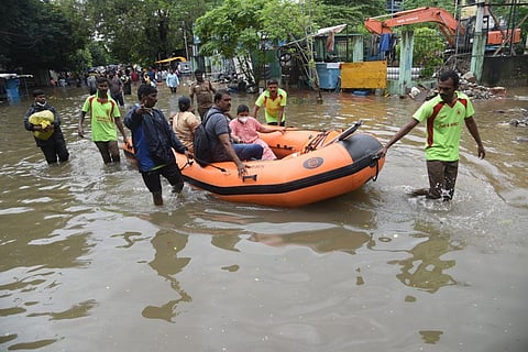
Meanwhile, the National Disaster Response Force (NDRF) has deployed four teams as requested by the Tamil Nadu government to handle the rescue and relief operations. One team each has been deployed in Tiruvallur and Chengalpattu while two teams were sent to Madurai. A 24x7 control room in Arakkonam is closely monitoring the situation in the state.