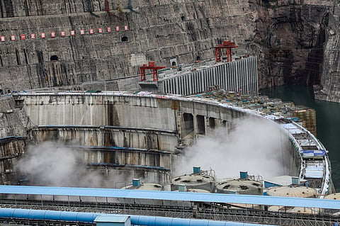
On December 25, the People’s Republic of China approved the construction of the world's largest hydropower dam on the Yarlung Zangbo River in Tibet at a site near the "Great Bend" close to the Indian border. The $137 billion project is supposed to produce about 300 billion kilowatt-hours of electricity annually, about three times that of the Three Gorges Dam.
The Yarlung Zangbo River flows as the Brahmaputra in India and Jamuna in Bangladesh and is popularly known as Siang/Dihang in Arunachal Pradesh. The Brahmaputra Basin spreads over four countries: China at 50.5%, India at 33.6%, Bangladesh at 8.1%, and Bhutan at 7.8%. It finally merges into the Bay of Bengal. The Brahmaputra is central to the regional ecology and livelihoods of the local population.
Geopolitical tensions and international norm violations
The absence of a comprehensive Brahmaputra Riverbasin (BRB) multilateral treaty creates several apprehensions for downstream countries, particularly changes in the effects of the flow of water, carrying silt and altering ecology.
Following the Doklam standoff between India and China in 2017, China unilaterally stopped sharing hydrological data as required by the MoUs, citing such technical reasons as damage to the monitoring stations due to floods. This act underlined how geopolitical tensions can make agreed mechanisms of data-sharing ineffective.
The MoUs did not have any provisions for joint monitoring or data validation and left the final decision regarding terms and timing of sharing to China. Failure to transit beyond data sharing, despite several MoUs since 2002, is also a cause of concern. The cooperation of China is still confined to sharing data for which agreements were made but with the complete denial to be a party to wider transboundary mechanisms of shared watercourses. This reflects a strategic aversion to genuine, fair engagements through binding contracts and a policy preference for sticking to control over water governance.
The implication of the China approach on the Brahmaputra River -- that is, hitherto, limited data sharing and unilateral project development -- falls highly short in terms of international legal principles.
The convention on the law of the non-navigational uses of international watercourses, 1997, calls for cooperation from the nations that share the watercourse on a binding undertaking of the states in using such resources equitably and reasonably. It also requires that states refrain from causing significant harm to other riparian states and attaches immense importance to prior notification and consultations on projects with possible transboundary effects.
China's construction of large-scale hydropower projects on the Brahmaputra, including the latest massive dam, violates the principle of prior notification or consultation with downstream countries like India, which is a binding norm under international water law. This move undermines the spirit of cooperation envisaged in the MoUs. The MoUs lack stringent enforcement mechanisms which allow China to withhold information selectively during critical times such as when dam-induced floods or landslides may affect lower riparians.
UN general assembly resolution 62/68 2007 says that states must prevent transboundary harm with precautionary measures and environmental impact assessments (EIA). In case one causes such damage, the state has a liability to mitigate and provide compensation.
The principle of sustainable development, in the moulds of various international laws, balances resource use against ecological preservation. Any project to be undertaken with effects on common water courses should be designed to meet the requirements for sustainable development.
The judgment by the International Court of Justice in the Gabcíkovo-Nagymaros Project (Hungary/Slovakia) affirms that states must undertake EIAs and also not act contrary to the environmental and economic interests of co-riparian states. The Iron Rhine Arbitration Case shows how environmental protection measures should be integrated into transboundary infrastructure projects and focuses attention on the principle of prevention. International law provides that states are under an obligation to ensure that activities within their authority do not cause environmental damage to other states or areas beyond national control. This supports the potential claims of India concerning adverse downstream impacts of China's dam.
Environmental and seismic risks of the mega-dam
The site proposed for the dam happens to be one of the most seismically active regions in the world. Its tectonic environment is complicated with many active fault systems, including the main Himalayan thrust, trans-Himalayan faults and Yarlung Zangbo suture zone. This region has also seen seismic events in history: the 1950 Assam-Tibet earthquake, with a magnitude of 8.6, shows the vulnerability of this region to major seismic hazards.
Having a mega-dam in such a high-risk earthquake zone raises questions about the structural integrity of the dam and also the consequences of seismic-induced failure. The dam could affect the livelihoods of the downstream countries as well. The dam will have a significant impact on agriculture in the downstream countries due to the altered sediment. The dam also increases the risks of the fishing communities relying on the Brahmaputra.
According to geological experts, other major concerns in the future include the risk of glaciers melting. The origin of the Brahmaputra River is from the Angsi glacier across the Himalayas. Glaciers contribute significantly to the flow of the river. Glaciers that melt may result in unstable glacial lakes which burst to cause catastrophic floods downstream. This reduces the weight on the earth's crust because of which isostatic rebound may also ensue, affecting seismic activity in the region. Glacial melting and climate change continue to shape the hydrology and sediment dynamics of the Brahmaputra Yarlung Zangbo River system.
The need for multilateral cooperation
The failure of the Banqiao Dam in China in 1975, which caused massive floods, and the ongoing impact of the Three Gorges Dam on the ecology and sediment flow should also be taken into consideration. We have a real-life example of the Mekong River and how China controls the upstream and the flow. China has constructed 11 dams on the Upper Mekong (Lancang River), significantly altering the water flow downstream. These dams have caused severe droughts in Thailand and Cambodia during the dry season while contributing to flooding during the wet season and destabilizing ecosystems and economies. The Southeast Asian countries are being affected by this, particularly in the dry season.
More than the hydropower ambitions of China, the approval for this mega-dam raises significant concerns about geopolitical intentions. Besides the environmental and seismic issues, the concerns regarding manipulating the flow of the river and the possibility of its usage as a water weapon during any bilateral crisis cannot be ruled out. While the hydropower aspirations of China are in tune with its renewable energy goals, the proposed dam on the Yarlung Zangbo River gives rise to significant seismic, environmental, geopolitical and legal challenges.
China, as the upper riparian country, controls the water flow, while lower riparian countries have limited leverage. The concerns of the other riparians -- India, Bangladesh and Bhutan -- need to be addressed through environmental impact assessments, commitment to international obligations, and meaningful engagement with all stakeholders. Data sharing is not the only way forward to address the geopolitical tensions of the downstream countries. India, Bangladesh, and Bhutan should advocate for a multilateral level framework that addresses the environmental concerns of the downstream riparians and the transparency in dam operations.
(The author is a policy analyst and independent researcher in international relations, public policy and global governance)
