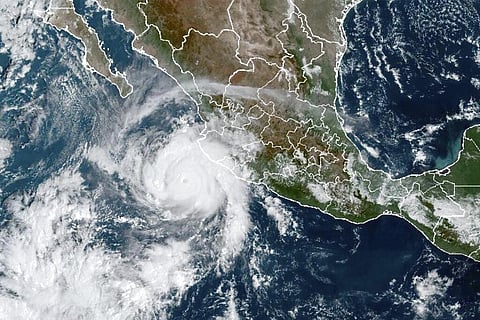

MEXICO CITY: Hurricane Roslyn was expected to deliver a treacherous storm surge to parts of Mexico Sunday after plowing over the Pacific as a powerful Category 4 storm just offshore from the resort of Puerto Vallarta.
The U.S. National Hurricane Center said early Sunday that Roslyn had become "extremely dangerous" with maximum sustained winds of 130 mph (215 kph).
The storm was forecast "to bring damaging winds, a life-threatening storm surge and flooding rains to portions of west-central Mexico today," the hurricane centre said at 12 a.m. Sunday.
The centre placed Roslyn's core about 45 miles (75 kilometres) west of Cabo Corrientes — the point of land jutting into the Pacific south of Puerto Vallarta — and moving north at 12 mph (19 kph).
Forecasters said Roslyn likely would pass close to Cabo Corrientes and the Puerto Vallarta region during the night, but warned that those areas would still see high winds, heavy rains and rough surf.
A hurricane warning was in effect for Las Islas Marias and Playa Perula to Escuinapa. A hurricane watch was in effect for the area north of Escuinapa to Mazatlan, the centre said.
The storm was expected to come ashore in Nayarit state Sunday morning. Hurricane Orlene made landfall on October 3 a little farther north in roughly the same region, about 45 miles (75 kilometres) southeast of the resort of Mazatlan.
Hurricane-force winds extended out 30 miles (45 kilometres) from Roslyn's centre, while tropical-storm-force winds extended out to 80 miles (130 kilometres), the U.S. hurricane centre said.
A hurricane warning was posted on a stretch of coast from Playa Perula south of Cabo Corrientes north to El Roblito and for the Islas Marias.
Seemingly oblivious to the approaching storm, tourists ate at beachside eateries Saturday around Puerto Vallarta and smaller resorts farther north on the Nayarit coast where the storm likely was headed.
"We're fine. Everything is calm, it's all normal," said Jaime Cantón, a receptionist at the Casa Maria hotel in Puerto Vallarta. He said that if winds picked up, the hotel would gather up outside furniture "so nothing will go flying."
While skies began to cloud up, waves remained normal, and few people appeared to be rushing to take precautions. Swimmers were still in the sea at Puerto Vallarta.
"The place is full of tourists," said Patricia Morales, a receptionist at the Punta Guayabitas hotel in the laid-back beach town of the same name, farther up the coast.
Asked what precautions were being taken, Morales said, "They (authorities) haven't told us anything."
The Nayarit state government said the hurricane was expected to make landfall around the fishing village of San Blas, about 90 miles (150 kilometres) north of Puerto Vallarta.
The head of the state civil defence office, Pedro Núñez, said, "Right now we are carrying out patrols through the towns, to alert people so that they can keep their possession safe and keep themselves safe in safer areas."
In the neighbouring state of Jalisco, Gov. Enrique Alfaro wrote that 270 people had been evacuated in a town near the hurricane's expected path and that five emergency shelters had been set up in Puerto Vallarta.
The National Water Commission said rains from Roslyn could cause mudslides and flooding. and the U.S. hurricane centre warned of a dangerous storm surge along the coast, as well as 4 to 6 inches (10 to 15 centimetres) of rain.