TEL AVIV: Omer Sharar had just received the first delivery of his new GPS anti-jamming technology when Hamas militants attacked Israel on Oct 7.
Since then, he and his team at InfiniDome, a start-up based in Caesarea, north of Tel Aviv, have been working around the clock to prevent the Israeli army's mini-drones from being intercepted by cheap and simple jamming in Gaza.
Israel—one of the world's main exporters of unmanned aerial vehicles (UAVs)—has for years waged a drone war along its borders, allowing it to monitor or target its enemies remotely with large, sophisticated airborne platforms.
During the war in Gaza, however, much smaller and cheaper drones, operated in far higher numbers, have come to the fore.
In recent years, Hamas has developed its own arsenal of low-cost mini-drones equipped with explosive charges.
On October 7, the militants put these devices to use, evading detection and interception to drop bomblets on military observation posts along the security barrier around the Gaza Strip as part of their unprecedented attack that triggered the war with Israel.
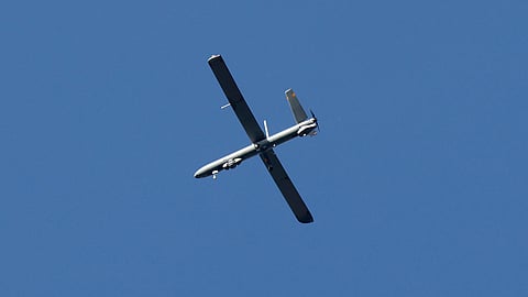
While Israel continues to use larger UAVs to observe the besieged Palestinian territory, with artificial intelligence suggesting targets to soldiers on the ground, its troops have also been supplied with mini surveillance drones.
These fly at very low altitude and are capable of entering buildings and tunnels to determine whether they are safe for soldiers.
Jamming and spoofing
Devices that use satellite navigation systems, such as the US-government owned Global Positioning System (GPS), function by receiving signals from multiple satellites orbiting the Earth and using them to calculate a precise location.
But the signal is weaker the closer it is to the ground, making it easy and cheap to jam with more powerful signals, leaving any GPS-reliant drones helpless.
Hamas fighters have been doing just that, prompting Israeli soldiers to secure their mini-UAVs with InfiniDome's GPSdome2 technology, which first came out in March 2023.
"We started delivering it to a couple of customers but actually, our first real production batch came more or less in September," Sharar told AFP.
In one sense, it was "perfect timing," with employees deployed as part of Israel's response to the October 7 attack, he said.
"A third of us got drafted immediately to reserve forces because we have UAV operators here. We have officers working in the company," he said.
Chief executive Sharar and the company's chief technical officer were not among them but set themselves to work as part of the war effort.
"Both of us got into the company on Saturday (October 7) and we started doing final testing and packing up GPSdome2 and we started distributing them," he added.
As well as defending its own GPS use, Israel has taken measures to disrupt the GPS of Hamas and other opponents.
The specialist site gpsjam.org, which compiles geolocation signal disruption data based on aircraft data reports, reported a low level of disruption around Gaza on October 7.
But the next day, disturbances increased around the Palestinian territory and also along the border between Israel and Lebanon in the north.
The Israeli army said in the following days that it disrupted GPS "in a proactive manner for various operational needs."
It warned of "various and temporary effects on location-based applications."
One AFP journalist on Abraham Lincoln Street in Jerusalem, for example, appeared as being in Nasr City, Cairo, on Google Maps.
Another in the West Bank city of Jenin was listed as being at Beirut airport on the navigation app Waze.
Hamas to Hezbollah
Todd E Humphreys and his team at the University of Texas at Austin track GPS signals in the Middle East and discovered an odd trend after October 7: the brief disappearance on screens of planes approaching Israel.
That was attributed to spoofing, whereby GPS data is manipulated to deliberately mislead a GPS receiver about its actual location.
"Our data are taken from satellites in low Earth orbit. Israel appears to be engaging in GPS spoofing as a defensive measure," Humphreys told AFP.
"The false GPS signals fool receivers in the area around northern Israel into thinking that they are at the Beirut-Rafic Hariri International Airport."
The war in Gaza has reignited tensions along Israel's border with Lebanon. There have been near-daily cross-border exchanges of fire between the army and Hezbollah militants backed by Israel's number one enemy, Iran.
Hezbollah has superior military capabilities to Hamas, including more sophisticated drones and precision missiles that can reach as far as the southern tip of Israel, its leader Hassan Nasrallah has said.
Sharar and his team have been learning every day from the war in Gaza but they have their eyes firmly fixed on Lebanon, which, he said, "potentially might be a lot more explosive."
