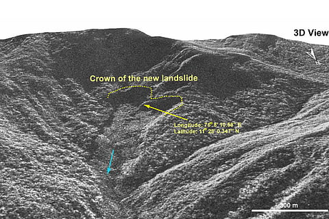
High-resolution satellite images from the Indian Space Research Organisation (ISRO) have revealed extensive damage in Wayanad days after a deadly landslide left over 250 people dead. The scale of the destruction has hampered ongoing rescue operations, with approximately 86,000 square metres of land having slipped and debris flowing nearly 8 kilometres along the Iruvazhinjiphuzha River.
To capture the devastation, the National Remote Sensing Center (NRSC) in Hyderabad deployed ISRO's advanced Cartosat-3 optical satellite and the RISAT satellite, which can penetrate cloud cover. The Cartosat-3 satellite captured pre-event images on May 22, while the RISAT satellite captured post-event images a day after the landslide on July 31.

The satellite data also reveals an old landslide at the same location, underscoring the area's vulnerability to such disasters. According to the NRSC report, the recent landslide was worsened by a major debris flow triggered by torrential rains in and around Chooralmala town.
Rescue and relief operations continued for the third day in Wayanad, with the death toll from Tuesday's landslides rising to 277 and at least 240 people still missing.
State health minister Veena George reported that 256 autopsies have been completed and 154 bodies have been handed over to the district administration.
Several people remain missing in the landslide-hit region, where rescue operators are contending with adverse conditions, including waterlogged soil, as they search through destroyed homes and buildings for survivors or bodies.