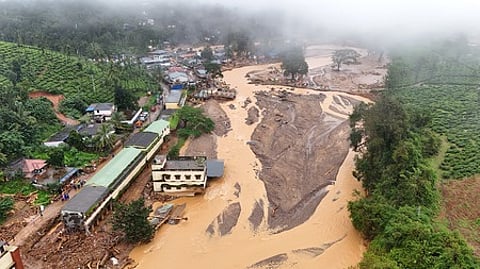

KOTTAYAM: Since the landslides in Wayanad that devastated Mundakkai and Chooralmala last year, experts and scientists have stressed the urgent need for people-centric early-warning systems to predict landslides at a hyper-local level.
A year after the tragic disaster, a glimmer of hope has emerged with the launch of a pilot project by the Cochin University of Science and Technology (Cusat) in the eastern high range areas of Kottayam district.
In response to the increasing frequency of landslides and localised floods triggered by extreme rainfall, Cusat has partnered with the Indian Institute of Space Science and Technology (IIST), Thiruvananthapuram, and the Environmental Resources Research Centre (ERRC), Thiruvananthapuram, to implement a social responsibility initiative titled ‘Creating an Automated Warning System for Landslides in Landslide-Susceptible Zones of the Meenachil River Basin’.
As part of the project, three automatic weather stations (AWS) have been set up in Teekoy, Poonjar Thekkekara, and Moonnilavu panchayats within the Meenachil river basin. This has been made possible with the support of NewSpace India Limited (NSIL), operating under the Indian Space Research Organisation (ISRO).
In its second phase, the project will see the installation of low-cost landslide prediction equipment in the region. The primary aim is to develop and test the operational feasibility of a reliable and robust observation and early warning system with active community involvement. The initiative is being implemented in collaboration with the Meenachil River Protection Committee.
“This is a research project. We need community participation in defending against natural disasters in the future. We are trying to integrate the data we collect with advanced technologies and the findings of the local community’s rain mapping system,” said Dr S. Abhilash, Director of Cusat’s Advanced Centre for Atmospheric Radar Research.
Key environmental parameters such as wind speed, humidity, temperature, rainfall, soil moisture, and soil temperature are being continuously monitored by the automated weather stations and landslide prediction centre. This data is transmitted in real-time to servers at Cusat for comprehensive analysis, forming the backbone of the early warning mechanism.