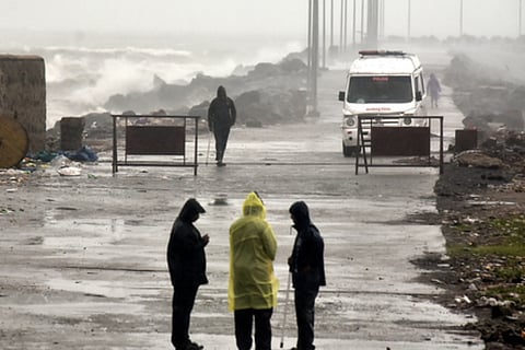
CHENNAI: A stubborn, slow-moving weather system that defied forecasts for two days slammed Chennai and its neighbourhood with intense rain on Monday, sharply reversing expectations after appearing to weaken over the weekend.
Meteorologists described the deep depression, the remnant of Cyclonic Storm Ditwah, as a “highly complex and poorly modelled” system that exposed the limitations of numerical weather prediction in the Bay of Bengal.
According to the met office, the deep depression is expected to weaken gradually into a depression. However, as it will continue to hug the coast and remain within 30 km of Chennai, moisture convergence is likely to persist.
"Tuesday will also see heavy rain over Chennai, Kancheepuram, Chengalpattu and Tiruvallur," said N Senthamarai Kannan, director of Area Cyclone Warning Centre.
Challenging to read from the start
From issuing an orange alert at noon on Monday to upgrading it to a red alert barely four hours later, the Regional Meteorological Centre (RMC), Chennai, was forced to respond to a rapidly evolving atmosphere. This system has been challenging from the beginning.
There were multiple circulations in the open ocean, interaction with the Sri Lanka landmass, fluctuating wind shear and at least two false starts in convection buildup. All this made Ditwah an erratic system.
Ditwah lost most of its convection after crossing Sri Lanka, where it caused significant damage. As it approached Tamil Nadu on Sunday, its core became exposed, typically a sign of collapse. This led to almost no rainfall over Chennai despite the orange alert, prompting many to assume the worst was over. But just when everyone thought Ditwah would disintegrate, it changed behaviour.
It stalled off Chennai, tapped into warm ocean pockets, rebuilt its cloud mass and began feeding moisture straight into the coast. For weak, slow-moving systems this is not unusual, but the timing caught everyone off guard.
Weather blogger Pradeep John was among those who admitted he had been caught by surprise.
By late night Monday, in a post on X, he was highlighting the intensifying cumulonimbus (Cb) clouds over the Bay of Bengal off Chennai, predicting that they would move inland and develop into steady, potentially heavy rain due to the stalled depression.
In an earlier post, he had said that the circulation will move even closer to Chennai on Tuesday.
At 11.30 am on Monday, Ditwah’s remnant deep depression was centred just 50 km east of Chennai, drifting northwards at a sluggish 3 kmph. Its minimum distance from the north Tamil Nadu coast was only 35 km—close enough for persistent feeder bands to hammer the city through the day.
Rainfall recorded between 8.30 am and 7.30 pm showed that the Chennai automatic weather station received the highest rainfall of 132 mm, the city’s heaviest spell of the monsoon, while Puzhal ARG topped the charts with 129 mm. Rainfall was sharply localised.
“Such spatial contrast is typical when a circulation is asymmetric and its rainbands repeatedly hit the same corridor,” said a climatologist.
How Ditwah highlighted an existing forecasting gap
Former IMD Director-General KJ Ramesh said the Ditwah episode highlights a persistent forecasting gap for systems hugging the coastline.
“When a system sits close to the coast, intensity changes happen within hours. Currently, IMD runs weather models once in the morning and once in the evening. What we need is a high-resolution rapid refresh that will capture what is happening during the day. IMD has started work in this direction and is doing experiments. IMD is experimenting with a 1.5-km-resolution system, but it needs fine-tuning and validation specifically for peninsular cyclones. Even a weakening depression can dump 20 cm of rain, as we have witnessed in the past.”
Schools, colleges to remain closed on Tuesday
With Monday receiving more rainfall than earlier anticipated from the remnant of Cyclonic Storm Ditwah, causing inconvenience to school-going children, the government announced a holiday on Tuesday for schools and colleges in Chennai, Kancheepuram, Chengalpattu and Tiruvallur districts as a precautionary measure.
Following separate announcements regarding the holiday by the Collectors of these districts, Anna University said it was cancelling the university examinations scheduled for Tuesday in these districts alone.
The University of Madras also said it was cancelling the semester examinations scheduled for Tuesday. Both universities said that a fresh date would be announced later.
