CHENNAI: Cyclonic Storm Ditwah over the southwest Bay of Bengal and adjoining north Sri Lanka continued to track north-northwestwards on Saturday, triggering a red alert for north Tamil Nadu, Puducherry and adjoining south Andhra Pradesh coasts. The system moved at about 8 kmph in the six hours ending 8.30 am and remained nearly stationary over the same region.
The cyclone was located about 80 km east of Jaffna, 140 km southeast of Vedaranyam, 170 km south-southeast of Karaikal, 280 km south-southeast of Puducherry, and 380 km south of Chennai. IMD said the system is very likely to continue moving north-northwestwards and reach the southwest Bay of Bengal, close to the north Tamil Nadu–Puducherry–south Andhra Pradesh coasts, by early Sunday morning.
As it tracks parallel to the coastline, Ditwah will come within 60 km of the Tamil Nadu coast by midnight Saturday, 50 km by early Sunday, and 25 km by Sunday evening. Models suggest the system may weaken and brush past the Chennai coast on Sunday evening as a Deep Depression.

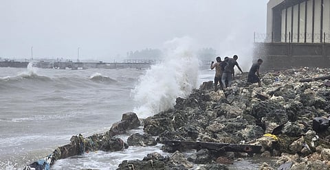
Heavy to very heavy rains have already set in across the Delta. Nagapattinam district, particularly locations close to the coast, has received 175–250 mm rainfall since midnight, with intense bands continuing to strike the shoreline. Rainfall is expected to persist over the Delta until evening as the core of the cyclone remains offshore.
As Ditwah drifts up the coast, the rainfall belt will gradually shift from Nagapattinam and Mayiladuthurai towards Cuddalore and Puducherry. Subsequently, showers will push into KTCC—Kancheepuram, Tiruvallur, Chennai and Chengalpattu—from today evening/night. Initial impact will be felt along the ECR stretch before spreading inland. Moderate to heavy spells are likely, with Sunday poised to deliver the most significant rains for Chennai.
Fishermen have been advised to stay away from the sea, and authorities are on alert for localised flooding, especially in coastal and low-lying areas.