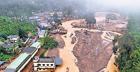

NEW DELHI: A recent attribution study by a group of global climate scientists found ample evidence of global warming in the Wayanad landslide disaster last month. A deadly cocktail of climate change along with increased deforestation and quarrying in the region increased the monsoon rainfall intensity by 10%, which triggered the landslides, the study concluded.
Attribution study is a fast growing field of climate science that tries to spot traces of climate change in extreme weather events using different climate models. It compares the world as it is today to a counterfactual situation without the 1.3°C global warming that we experience at present.
The attribution study of the Wayanad landslide disaster was conducted by the World Weather Attribution (WWA), an international collaboration of climate scientists who do rapid assessments of extreme weather events.
What happened on July 30
In the wee hours of July 30, Wayanad district received record rainfall, which triggered catastrophic landslides in the villages of Mundakkai and Chooralmala. These villages are situated on the eastern slopes of the Vellarimala hills and a key tributary of the Chaliyar river flows near both the villages.
The initial landslide in Mundakkai was followed by three more within a span of three hours, destroying Chooralmala, Attamala and Mundakkai. It also resulted in the collapse of the main bridge connecting the affected areas to the nearest town, hindering rescue operations. The disaster resulted in over 300 fatalities, with hundreds more reported missing.
The heavy rains caused the hillside to give way, unleashing torrents of mud, water and boulders that swept through the affected areas. The landslide began at an altitude of 1,550 metres, resulting in approximately 86,000 square metres of land being displaced. This landslip occurred less than 5 km from a previous landslide site in 2019, which had resulted in 17 casualties.
Fingerprints of Climate Change
It’s well established that the increasing volume of greenhouse gases in the atmosphere due to large scale use of fossil fuels causes global warming that leads to climate change. Currently, the world is warmer by 1.3°C than it would have been at the dawn of the industrial revolution.
The common scientific understanding is that a warmer atmosphere can hold more moisture, leading to heavier downpour. Megacities and different regions of the world, which had no previous history of floods, are witnessing heavy downpour, damaging lives and properties.
“Under a future warming scenario, climate models predict even heavier 1-day rainfall events, with a further expected increase of about 4% in rainfall intensity,” said Mariam Zachariah, researcher at the Grantham Institute - Climate Change and the Environment, Imperial College London, which is a WWA partner. Zachariah pointed out that air can hold around 7% more moisture for every 1°C of temperature rise.
Scientists investigated the disaster after analysing different climate models with high enough resolution to capture precipitation over relatively small study regions.
The overall climate models indicate a 10% increase in the rainfall intensity on July 29-July 30 morning.
The disaster occurred in a mountainous region with loose, erodible soil after over 140 mm of precipitation on saturated soils. The heavier precipitation in Wayanad on July 30 was the third highest after 2019 and 1924.
According to the study, there has been a trend of rising intensity of rainfall in Southern India during the summer monsoon between 1971 and 2017. Over the years, the land use and land cover (LULC) changed drastically in the region due to urbanisation and changes in forest types — from dominant mixed forests to deciduous needle/leaf forests. Experts explain that increased urbanisation led to higher surface temperatures, increased heat fluxes and more intense rainfall.
Mixed impact of land use changes
The WWA study found that LULC changes had a mixed impact on landslides. After analysing 90% of landslides that occurred in Kerala between 2010 and 2018, they found no noticeable LULC changes over the two preceding years.
However, 25% of the landslides originated in forest plantations and built-up areas. It has been suggested that land-use changes may indeed have played a role in these disasters. A bigger proportion of the landslides (58%) in the district occurred in densely vegetated areas.
The study underlines two recent landslide events as examples of how LULC caused disasters. In the 2018 Wayanad landslides, the causative factors were infrastructure development and stone quarrying. In the following year, unsustainable rubber cultivation practices on the steep slopes (up to 30 degrees) were a major culprit for the landslides, including operating heavy earth movers to dig large rain pits, which, when waterlogged by the heavy monsoon, acted as a trigger. Moreover, poor water drainage management and residential units were the causative factors.
Last month’s landslides were also attributed to the huge deforestation in the Wayanad district that has altered its face. Between 1950 and 2018, Wayanad lost 62% of its green cover, with tea plantation areas increasing by approximately 1,800%, resulting in reduced forest cover to stabilise the hills. The study pointed out that Wayanad’s plantations have continued to expand from 913 sq km to 1,215 sq km while forests shrunk from 888 sq km to 672 sq km since 2012. (see map)
The study underscored the need for a more robust and localised early warning system that can provide accurate, timely, and actionable alerts to vulnerable communities.