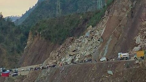

NEW DELHI: A recent landslide in Sikkim created a furore since it came a year after another disastrous landslip in the Himalayan state. This time, the landslide was not due to extreme weather as it happened in dry conditions. It posed a serious challenge to policymakers who routinely push huge hydro infrastructure projects in the fragile Himalayan region.
Around 7.30 am on August 20, a massive landslide took place in Balutar. It substantially damaged the Teesta V, a 510 MW hydel power station, and a GIS building located at Dipu Data on the Teesta river, 20 km southwest of Gangtok. Fortunately, no lives were lost though there was significant infrastructure damage.
This disaster comes on the heels of the Glacial Lake Outburst Floods (GLOF) and riverine floods in the Teesta River basin on October 4, 2023, which caused massive devastation in Sikkim and Kalimpong in West Bengal. The National Highway-10, the lifeline of Sikkim and Kalimpong, which runs along the Teesta, has been in a precarious state following frequent landslides and closures.
According to the International Hydropower Association (IHA), the station has an 88.6-metre high, 176.5 metre-long, concrete gravity dam with open reservoirs for daily power peaking. It is located around 18 km upstream at Dikchu and connects through underground tunnels to the powerhouse. It operates as a peaking plant during winter and at continuous full power during summer. However, the plant has been out of operation since last year’s October flood, which had seriously damaged it.
Incidentally, in 2021 the National Hydropower Company’s (NHPC) Teesta V power station was conferred the Blue Planet Prize by IHA during the World Hydropower Congress 2021. In 2019, the power station was showcased as an example of global good practices in hydropower sustainability. The Hydropower Sustainability Assessment Protocol found the Teesta V met or exceeded international good practice benchmarks across all 20 performance criteria, including environmental viability and sustainability.
However, local people, whose lives have been affected since the advent of the project, termed these awards as an eyewash to hide the unsustainable practices. “These awards are an attempt to hide the plight of the people whose lives were turned upside down during the past 18 years due to a series of projects on the Teesta,” alleged Gyatsho Tongden Lepcha, general secretary of the Affected Citizens of Teesta (ACT), an NGO.
The plant is part of a cascade of six projects on the Teesta River to harness 3,635 MW power within 175 kms of the river in Sikkim. ACT claimed that the government was only concerned about the collapse of the dam but not the project’s role in the disaster. Besides, they always blame it on natural events instead of taking a serious look at their broken hydro policy, it alleged.
At present, 47 hydropower projects of the National Hydropower Development Corporation are in different stages of development on the Teesta River in Sikkim and West Bengal. Nine of them have been commissioned, work on 15 dams is going on and another 28 are in the pipeline.
Besides, IRCON has undertaken tunnelling of this sensitive region for the Sivok-Rangpo railway line (14 tunnels), accentuating the region’s vulnerability.
Senior Congress leader and former Union environment minister Jairam Ramesh criticised the Union government for mismanaging the Himalayan state and making it disaster-prone by allowing unplanned hydro projects. He also alleged that the government didn’t release funds in time for irrigation and flood mitigation after last year’s disaster.
Experts’ take
A peculiar feature of the Sikkim landslide was that it happened in a dry situation instead of extreme weather conditions, such as heavy rainfall. The region didn’t receive much rain since August 8 and its deficiency varied from -42% to -88%. However, on August 19, there was 38 mm of rainfall, which was 100% more than normal. “We do not see any role of extreme weather incidents in this landslide. Except on August 19, the area received deficient rainfall since the past two weeks,” said Dr G N Raha, a scientist at the Met Centre in Gangtok.
Experts concur that the Centre needs to re-consider such hydro projects. “Are we ready for such a geological surprise?” asks Himanshu Thakkar of the South Asia Network of Dams, Rivers and People. Thakkar says Sikkim’s landslides were the result of ‘improper’ geological assessment before construction in 2008.
“Such projects would repeatedly fail if complex geological settings of the region keep getting ignored,” Thakkar adds.
Another expert said severe man-made alterations might have induced the landslide. Blasting and construction activities for tunnels could have unsettled the slope, he reasoned. “Was the slope cut to create a bench for the power infrastructure?” asks Dave Petley, who is widely recognised as a world leader in the study and management of landslides. Petley’s comparative analysis of images of the site from 2011 and 2024 sourced from Google maps suggests a change in the slope.
“While I cannot say definitively, there are indications in this image that the slope may have been altered. If so, construction activities damaged the integrity of the slope which slid. It raises serious questions about engineering at the site,” observes Petley.
The situation is only getting worse as warming due to climate change in these elevations are causing more intense rainfall and thus more landslides.