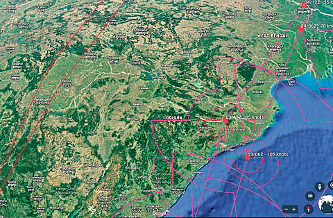
BHUBANESWAR: Gradually gathering strength, tropical cyclone Fani tracked north-northwestwards over the Bay of Bengal for a May 3 brush with Odisha. If its current speed and intensity are any indication, it would cross the coast closer to Puri and move along the coast.
As it packed power, the Odisha Government alerted all districts while issuing special instructions to 14 coastal and interior districts to remain vigilant. Evacuation of the elderly, women, children and physically challenged to cyclone shelters would commence from May 2 from the coastal districts. While the Centre pushed at least 28 NDRF teams, including 10 from outside the State, the Odisha
Government started deploying 20 ODRAF units for rescue and relief operations. It has also sought two helicopters from the Centre to assist in the post-calamity operations.
Fani, now an extremely severe cyclonic storm, is expected to intensify further and may make landfall between Gopalpur and Chandbali on May 3 afternoon, Director, India Meteorological Department, Odisha HR Biswas said.
The storm will move northwestwards till May 1 and recurve north-northeastwards to hit Odisha coast with maximum sustained wind speed of 170-180 kmph and gusting upto 200 kmph, Biswas said. Storm surge of around 1.5 metre height is likely to inundate low lying areas of Ganjam, Khurda, Puri and Jagatsinghpur districts at the time of landfall.
The peculiarity of Fani, according to meteorologists, is its track which lay closer to the coast all along its path. Unlike in the past when cyclones would head into the land and weaken, Fani is expected to track alongside the coast from Puri towards Mayurbhanj. It would get enough moisture support from the sea while the existing hot and dry conditions on the land would be favourable. “That’s why it does not appear to be losing intensity after making the landfall,” Director of Centre for Environment and Climate of SOA University Dr Sarat Chandra Sahu said. Besides, the summer conditions may also cause strong thunderstorm activities.
Currently, the storm lay centred over southwest and adjoining westcentral and southeast of Bay of Bengal about 760 km south-southwest of Puri in Odisha and 560 km south-southeast of Visakhapatnam in Andhra Pradesh, moving at a speed of 21 kmph since last six hours.
According to the IMD, the storm will induce heavy rainfall in south Odisha and south-interior Odisha on May 2 and coastal Odisha and adjoining districts on May 3 and 4.
It has already issued orange alert for Gajapati, Ganjam, Puri, Khurda, Rayagada and Kandhamal districts on May 2 and red warning for 25 districts including Khurda, Cuttack, Jagatsinghpur, Jajpur, Puri, Bhadrak, Ganjam, Kendrapara, Balasore and Angul on May 3. In view of the rough sea conditions during next 72 hours, the IMD has also advised fishermen those who are out in deep sea areas to return to coast by May 1.
On Tuesday, the Government prepared its evacuation plan and sought two helicopters from the Centre to carry out evacuation and rescue operation in the affected areas. Chief Secretary Aditya Prasad Padhi said the Government is prepared to deal with any eventuality. The NDMA and ODRAF teams have been asked to remain prepared while district administrations have also been alerted.
