NEW DELHI: Experts emphasize the need for an accurate early warning system (EWS) that correlates rainfall with the potential for landslides, as heavy rains wreak havoc in hilly regions across India. The recent landslides in Kerala's Wayanad have buried entire homesteads and possibly hundreds of people, highlighting the urgent need for improved disaster preparedness.
On Thursday, cloudbursts in Himachal Pradesh led to the destruction of houses, bridges, and roads, resulting in five deaths and 50 people missing. In Uttarakhand, heavy rains triggered floods and house collapses, killing at least 14 people.
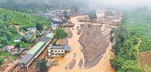
These tragedies follow the extreme rainfall in Wayanad, Kerala, where over 570 mm of rain fell in 48 hours, causing landslides that left at least 195 people dead. The increasing frequency of erratic rain, extreme weather events, and changing climatic conditions, combined with the fragile geology of both northern and southern hill regions, underscores the need for an accurate EWS based on empirical rainfall thresholds and a systematic evacuation protocol.
"EWS is important to understand which areas and communities are vulnerable. It helps establish mitigation measures, including evacuation," said Nilmadhab Prusty from the Centre for Development and Disaster Management Support Services.
Currently, India lacks granular studies or an EWS for landslide forecasts. In Kerala, for example, the Geological Survey of India (GSI) provided a forecast on July 29 for two days but failed to predict the severity of the disaster that struck early on July 30. The Kerala State Disaster Management Authority (KSDMA) receives forecasts in four categories: very high possibility, high possibility, moderate possibility, and low possibility. However, these forecasts are often insufficiently specific.
"The 'Experimental Rainfall Induced Landslide Forecast Bulletin' for Wayanad district forecasted only a 'low possibility of occurrences of landslides,' which did not indicate the potential for widespread or moderate landslides," said P.M. Manoj, press secretary of the KSDMA.
Kerala approved three pilot projects for state-specific landslide early warning systems in 2020, but none have been completed. The GSI reports that about 0.42 million square km (nearly 12.6% of India's land area) is prone to landslides, including all Himalayan states, sub-Himalayan terrain of the northeast, and the Eastern and Western Ghats states.
Effective evacuation protocols are also crucial. Despite KSDMA's network of locally trained disaster management personnel and mechanisms to disseminate early warnings, many residents in hilly areas did not evacuate when advised, as they did not anticipate the disaster's severity.
In December 2017, the National Disaster Management Authority (NDMA) launched a pilot project for 'Low-Cost Landslide Monitoring Solutions,' but it was limited to Himalayan states and has seen little progress since.
A community-run effort, Satark, in Maharashtra, aims to improve landslide awareness and issue alerts in the Sahyadri ranges. The Pune-based non-profit Centre for Citizen Science (CCS) started Satark in August 2015, after the Malin village landslide in Pune district left 151 dead. The CCS has mapped landslide incidents over the past 20-25 years in the Sahyadri ranges and monitors rainfall daily during monsoon seasons.
The CCS issues notifications at three levels: Watch, Alert, and Warning. "After continuous rainfall, we monitor the accumulated rainfall and issue specific village-level alerts using radar images," said Mayuresh Prabhune, a founding member of CCS. The Satark model showed 76.5% success in predicting landslides one day in advance, according to a March 2022 study published in the journal Land.
The 2020 study by researchers from Indore, Italy, and Australia identified a threshold of 24 mm of daily rainfall as sufficient to trigger landslides in Wayanad. This finding emphasizes the need for localized thresholds for landslide warnings.
The NDMA released 'Guidelines on Management of Landslides and Snow Avalanches' in June 2009, followed by a 'Landslide Risk Mitigation Scheme' in 2014, highlighted in the National Disaster Management Plan of 2016 and updated in 2019. However, the need for low-cost landslide early warning systems remains unmet, and states are responsible for managing such disasters.
"Early warning systems have two parts: generating accurate alerts and effectively communicating them to the relevant people," explained Sanjay Srivastava, a member of the NDMA's Experts Group.
The recent disasters in Wayanad, Himachal Pradesh, and Uttarakhand underscore the urgent need for robust early warning systems and comprehensive evacuation protocols to mitigate the impact of landslides.
